How AI and machine learning are revolutionizing weather forecasting with unprecedented accuracy and saving lives.
Okay, So This Has Been Bugging Me
I’ve been stewing on this for months now and I think it’s finally time to write it down. Last September, my daughter had a soccer tournament in Austin, Texas. Blue sky. Not a cloud in sight. Apple Weather said clear skies all afternoon, pulling from the standard National Weather Service models, so naturally I left the umbrellas in the car like a normal person. Forty-five minutes into the game? Thunderstorm. Parents sprinting across the parking lot with folding chairs over their heads. Kids sliding through mud in their cleats. And when I checked my phone afterward, the forecast had quietly updated itself to show rain. Oh, thanks. Really helpful.
But here’s what got under my skin. A friend standing right next to me had a different app, one pulling data from Google DeepMind’s GenCast model, and it had flagged the storm two hours before it hit. She had rain jackets. Dry clothes for her kid. She looked at me like I was still using MapQuest. That was probably the moment I started actually digging into what machine learning was doing to weather prediction, and six months later I’m a little annoyed that nobody told me sooner. We’re in the middle of a quiet but pretty dramatic shift in how forecasting works, and most people have no idea.
Why Old-School Forecasting Stopped Getting Better
Alright, so to understand why any of this matters, you need to know how traditional weather prediction actually works, and why it’s been stuck. Conventional numerical weather prediction (NWP) has been the backbone of meteorology since the 1950s. Divide the atmosphere into a 3D grid. Solve the Navier-Stokes equations, thermodynamic equations, moisture equations at every single grid point. Step forward in time. Repeat. The models that national agencies run, the ECMWF’s Integrated Forecasting System, the American GFS) they’re sophisticated, sure. The ECMWF runs on some of the most powerful supercomputers on Earth, and it’s widely considered the best operational weather model out there.
And look, it works. Kind of. A five-day forecast today is about as accurate as a one-day forecast was back in 1980, according to ECMWF data. That’s real progress. But improvements have gotten agonizingly slow and stupidly expensive. Double the resolution? You need roughly ten times the computational power. A single global forecast on the ECMWF’s supercomputer takes hours and burns through significant energy, and it still can’t resolve a specific thunderstorm cell over my daughter’s soccer field. There’s a hard bottleneck here: physics-based modeling is computationally brutal, with diminishing returns that have been obvious for years.
I’ve talked to engineers who work on this stuff, and this is where they get excited. Because machine learning doesn’t solve the Navier-Stokes equations. It doesn’t need to. It learns patterns straight from decades of observational and reanalysis data, then spits out forecasts in seconds instead of hours. The question was always whether a statistical model could actually beat physics. And as of 2025 and 2026? The answer is an increasingly loud yes, and I’m honestly a bit frustrated that the traditional meteorology establishment seems to be dragging its feet on admitting it.
GenCast Showed Up and Made Everyone Look Slow
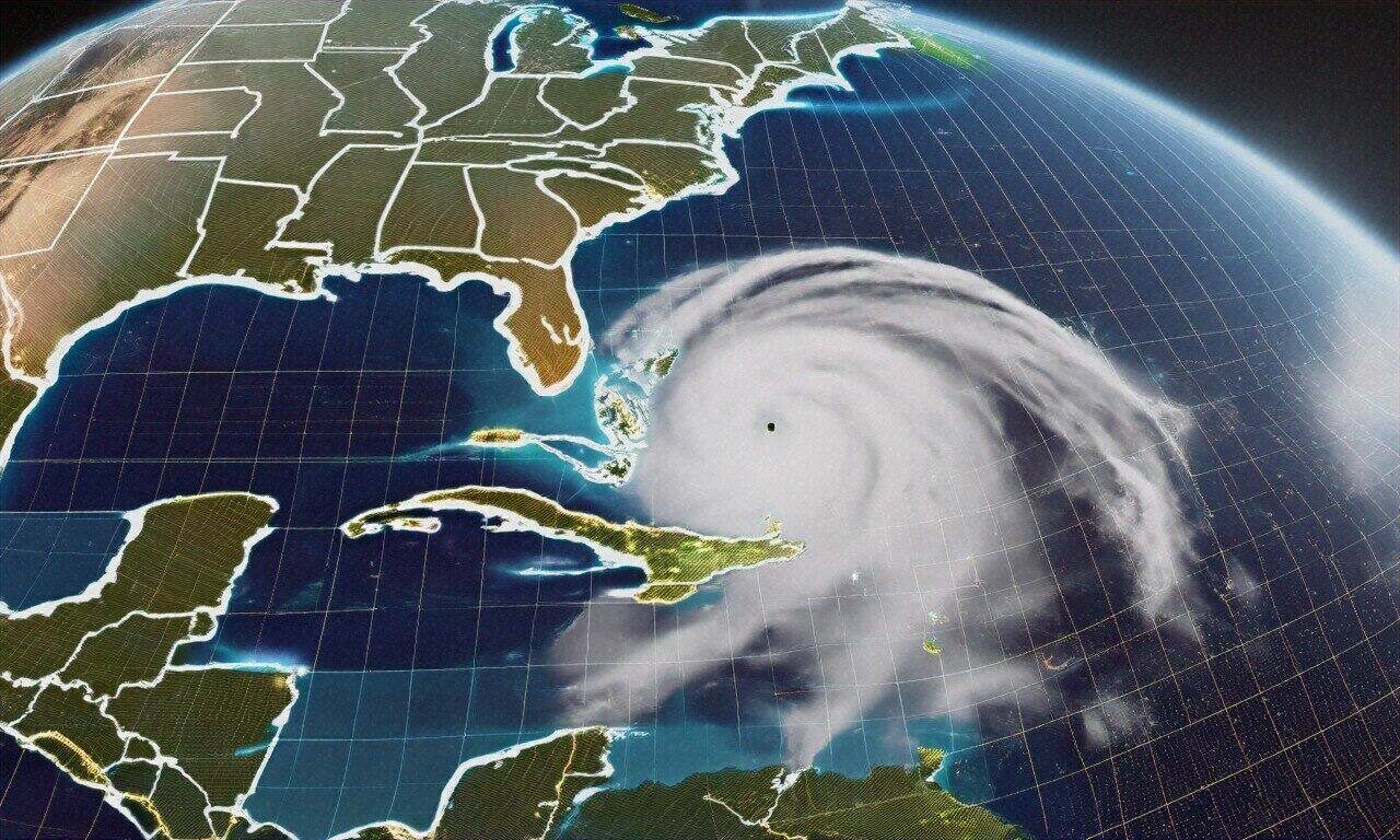
In December 2024, Google DeepMind dropped a paper in Nature introducing GenCast. It outperformed the ECMWF’s ENS ensemble forecast on 97.2% of 1,320 evaluation targets. Sit with that number for a second. 97.2%. The ECMWF model represents decades of work by brilliant atmospheric scientists and computational physicists, running on supercomputers that cost hundreds of millions of euros. GenCast beat it on basically everything. And it did this running on a single Google Cloud TPU v5 chip in about eight minutes. Not hours. Minutes.
GenCast uses a diffusion model architecture, same basic approach behind Midjourney and Stable Diffusion, but adapted for atmospheric data instead of generating pictures of cats wearing hats. It’s trained on 40 years of ERA5 reanalysis data from the ECMWF, which gives you a consistent historical record of global atmospheric conditions from 1979 to the present. Feed it the current state of the atmosphere, and it generates probabilistic forecasts: not one single prediction, but an ensemble of possible futures, each weighted by likelihood. That probabilistic piece matters a lot. Weather is chaotic by nature, and knowing the range of outcomes is often way more useful than a single point estimate that pretends to be certain.
What impressed me most when I talked to researchers who’d tested it? Extreme weather performance. Tropical cyclone track predictions were way more accurate than traditional models at lead times beyond five days. Wind speed forecasts at wind turbine hub height (which grid operators care about enormously, were markedly better. And the model showed real skill at predicting temperature extremes and heavy precipitation events, exactly the stuff traditional models tend to underestimate. I think the performance gap is only going to widen, too, but I could be wrong about the timeline.
Everyone Else Was Already Working on This (Which Is Kind of the Point)
GenCast got the headlines. Fine. But it’s part of something much bigger. Huawei’s Pangu-Weather, published in Nature in July 2023, was one of the first models to show that an AI system could match the ECMWF’s deterministic forecast. It uses a 3D Earth-specific transformer architecture and generates a seven-day global forecast in under ten seconds. Ten seconds. NVIDIA’s FourCastNet uses adaptive Fourier neural operators to model atmospheric dynamics and is particularly strong at predicting large-scale circulation patterns. Microsoft built ClimaX as a foundation-model approach, pre-train on diverse climate data, then fine-tune for specific prediction tasks.
Even the ECMWF isn’t sitting around. In 2024, they launched their own ML model called AIFS, the Artificial Intelligence Forecasting System. It combines machine learning with all their decades of domain expertise, using a graph neural network architecture that represents the atmosphere as nodes on an irregular grid. Captures atmospheric interactions at multiple scales. Early results are competitive with GenCast on several metrics, and they plan to integrate it into their operational pipeline by late 2026. Smart move. Probably should’ve started earlier, but that’s easy to say from the outside.
China’s been moving fast too. FuXi from the Chinese Academy of Sciences, FengWu from the Shanghai Artificial Intelligence Laboratory, both have demonstrated state-of-the-art performance on medium-range benchmarks. An engineer at one of these organizations told me, half-jokingly: “A new model that beats the previous best seems to come out every three months. We can barely finish evaluating one before the next drops.” That kind of competitive pressure drives progress faster than any amount of government funding. Maybe I’m being cynical, but the pace feels almost unsustainable, though that hasn’t stopped it yet.
Where ML Actually Crushes It (And Where It Doesn’t)
Not every type of weather prediction benefits equally from machine learning. The biggest wins show up in medium-range forecasting, roughly three to fifteen days out. That’s the sweet spot. Traditional models lose skill fast beyond about ten days because tiny errors in initial conditions amplify chaotically, which is basically what Edward Lorenz figured out in 1963 and we’ve been dealing with ever since. ML models, because they’ve absorbed the statistical structure of how weather patterns actually evolve, degrade more gracefully. GenCast maintains useful skill out to about fifteen days for large-scale patterns. That’s two to three days longer than the ECMWF’s operational model, and two or three extra days of useful forecast is a big deal when you’re talking about evacuation planning or energy grid management.
Extreme event prediction is another area where ML pulls ahead. Take tropical cyclone track forecasting: it’s gotten dramatically better. ML models can spot the atmospheric signatures that precede rapid intensification, when a hurricane’s wind speeds jump 30 knots or more in 24 hours. This matters because rapid intensification is what turns a manageable Category 1 hurricane into a catastrophic Category 4 overnight. Hurricane Otis in October 2023 is the case everyone brings up: went from tropical storm to Category 5 in under 24 hours, and traditional models were caught completely off guard. Post-hoc analysis showed that ML models, had they been operational then, would’ve provided earlier warning. People might have had more time to get out of the way. I find it maddening that we had the technology sitting in research labs while people were dying.
Renewable energy forecasting is maybe the most immediately impactful commercial application, and I don’t think it gets talked about enough. Wind and solar power generation are totally weather-dependent, bad forecasts mean wasted energy or blackouts. GenCast and similar models have shown 20-30% improvement in wind power prediction accuracy over traditional methods. For major grid operators, that translates directly into lower costs and more reliable electricity. Engie, one of Europe’s largest utility companies, announced in 2025 that it was integrating ML weather forecasts into its grid management systems. Estimated annual savings in the tens of millions of euros. Real money, real impact, and yet somehow this barely made the news.
The Problems Nobody Wants to Bring Up (But Should)
I’d be dishonest if I just told you the success story and left it there. ML weather models have real problems, and from what I’ve seen, the people building them are actually more candid about this than the hype articles would suggest. The biggest issue is physical consistency. Traditional weather models are constrained by the laws of physics — mass conservation, energy conservation, the Coriolis effect works the way it should. ML models have none of those constraints baked in. They learn correlations from data, and most of the time those correlations respect physical laws because the training data does. But not always.
ML models have been caught producing forecasts where moisture appears from nowhere. Temperatures that violate energy conservation. Wind patterns that are physically impossible. Rare? Yes. But they’re the kind of errors that make meteorologists deeply nervous, and honestly, I get it. When you’re issuing a hurricane warning that might trigger an evacuation of hundreds of thousands of people, “it’s usually right” isn’t quite good enough. You want to know that the model can’t hallucinate a physics-breaking scenario that sends everyone running for no reason, or worse, fails to flag a real disaster.
Then there’s the resolution problem, which is probably the most frustrating limitation if you’re a regular person who just wants to know if it’ll rain at your specific location. Most current ML weather models operate at grid spacings of 0.25 degrees, roughly 25 to 28 kilometers at mid-latitudes. Fine for predicting whether a weather system will hit the Austin metro area. Useless for resolving the specific thunderstorm that drenched my kid’s soccer field. High-resolution forecasting at the kilometer scale, what meteorologists call “convection-allowing” models, is where traditional NWP still holds a clear advantage. Google’s MetNet-3 operates at 1-4 kilometer resolution for short-term precipitation forecasting, but convective storms are way more chaotic and harder to predict than large-scale weather patterns. It’s a much harder problem, and progress is slower than I’d like.
Climate change adds another wrinkle that I think researchers are right to worry about. ML models learn from historical data, 1979 to 2023, in most cases. But the future atmosphere won’t behave like the past atmosphere. If the jet stream shifts in ways that have no precedent in the training data, the model might just.. not handle it. Traditional physics-based models, because they actually simulate the atmospheric equations, can in theory cope with novel conditions. Several research groups are working on hybrid approaches that combine ML’s speed with physics-based constraints. That hybrid path is probably where the field lands eventually, but we’re not there yet, and anyone who tells you otherwise is selling something.
The Infrastructure Angle That Everyone’s Ignoring
One of the most underappreciated parts of all this, and it genuinely annoys me that it doesn’t get more coverage, is what ML weather models mean for global forecasting infrastructure. Traditional weather prediction requires massive supercomputing centers. The ECMWF’s data center in Bologna, Italy, houses some of the most powerful computers in Europe. National weather services collectively spend billions on computational infrastructure worldwide. ML models? Single high-end GPU or TPU chip. Done.
Think about what that means for developing nations. Countries in sub-Saharan Africa, Southeast Asia, and the Pacific Islands, regions hit hardest by extreme weather) have historically lacked the computational resources to run high-resolution weather models. They’ve been stuck relying on global models from the ECMWF or NCEP (the U.S. National Centers for Environmental Prediction) that may not adequately capture local conditions. ML models running on modest hardware could democratize access to quality weather prediction in ways that directly save lives. Not in theory. Right now. The World Meteorological Organization recognized this potential and launched an initiative in 2025 to support ML weather forecasting capacity building in developing nations.
But (and there’s always a but, ML models need training data. Observational data in many developing regions is sparse, and it’s getting sparser. Weather station networks in sub-Saharan Africa have actually shrunk over the past two decades because of underfunding. Satellite data fills some of the gap, sure, but ground-truth observations still matter for training and validation. Nobody wants to talk about this because improving observational infrastructure isn’t as sexy as building a shiny new AI model. But it might be just as important for actually delivering on the promise of ML forecasting to the places that need it most. Probably more important, if I’m being honest.
What’s Actually Changed in Your Weather App
So when does this stuff show up on your phone? Some of it already has, and you might not have noticed. Apple baked ML-based precipitation forecasting into Apple Weather starting with iOS 17, powering the “next hour precipitation” feature in supported regions. Google’s weather app uses ML models for short-term precipitation nowcasting. The Weather Company (owned by IBM) has been using machine learning to post-process traditional model output, basically using ML to correct the biases in physics-based forecasts, for several years now.
Full integration of models like GenCast into consumer-facing forecasts, though? Still in progress. The main barrier isn’t technology. It’s institutional. National weather services are cautious about swapping out decades-proven physics-based models for relatively new ML approaches, and I understand the caution even if I find the pace irritating. The ECMWF is running AIFS alongside its traditional IFS model and comparing results before committing to operational use. The U.S. National Weather Service has been even more conservative, citing those physical consistency concerns I mentioned. From what I can tell, they’re being careful. Maybe too careful, but that’s a judgment call I’m not really qualified to make.
My prediction, and yeah, I see the irony of making predictions in a piece about prediction) is that by 2028, the primary forecast models at most national weather services will be either ML-based or hybrid ML-physics systems. The performance gap is too large to ignore, and the cost savings from reduced computational requirements create strong institutional incentives. Your weather app in 2028 should be meaningfully more accurate than the one you’ve got right now, especially for extreme weather events and forecasts beyond five days. Seems likely, anyway.
Why This Is Bigger Than Weather
What’s happening in weather prediction isn’t just a meteorology story: and I think that’s what keeps pulling me back to it. It’s a test case for whether machine learning can outperform physics-based simulation in complex natural systems. And the answer is reshaping multiple fields at once. Climate modeling. Ocean current prediction. Earthquake early warning. Wildfire spread forecasting. Air quality prediction. All of these are systems governed by well-understood physics but with chaotic dynamics that make precise prediction absurdly expensive computationally. Same basic pattern: physics knows the rules, but the computation is killing us.
I talked to a senior researcher at NVIDIA working on their Earth-2 digital twin initiative, a project to build a GPU-accelerated simulation of Earth’s climate system combining traditional physics with ML. She said something that stuck with me: “Weather prediction is the proof of concept for a much bigger idea. If we can show that ML improves weather forecasts, it validates the approach for climate projections, which is where the really big decisions depend on accurate long-term prediction.” Infrastructure. Agriculture. Water resources. Migration planning. All of it flows downstream from whether we can predict what the atmosphere is going to do.
And that’s the real stakes here. Getting forecasts right isn’t about whether I bring an umbrella to a soccer game. It’s about whether coastal cities invest in flood defenses. Whether farmers plant the right crops for shifting seasons. Whether grid operators can reliably integrate renewable energy without brownouts. Whether emergency managers can evacuate people before a hurricane makes landfall instead of after. ML is making every single one of those predictions better, and the pace of improvement doesn’t seem to be slowing down. If anything, it’s accelerating in ways that caught even the researchers off guard.
What I Actually Use Now
After six months of obsessively testing weather apps (my wife thinks I’ve lost my mind), here’s where I’ve landed. For daily forecasting, I run a combination of Apple Weather and Windy, which lets you toggle between different model outputs — ECMWF, GFS, ICON, and others. For severe weather alerts, I stick with the NOAA Weather app because the National Weather Service’s warning system is still the most reliable for life-safety decisions. For anything beyond a week out, I check the ECMWF’s extended-range probabilistic forecasts, which increasingly include ML post-processing.
But the one that surprised me most was Google’s weather implementation in the Google app. It quietly started using ML precipitation nowcasting that’s noticeably more accurate for “will it rain in the next two hours?” than anything else I’ve tested. Not perfect (nothing is, but the improvement over even twelve months ago is striking, and that track of rapid improvement is what makes me think we’re heading somewhere good with this tech.
Last week my daughter had another game. Same field in Austin, actually. Checked three different apps before we left the house. All three said scattered storms by late afternoon. I packed rain jackets, a tarp, dry socks, the whole bit. We got there, set up, and the sky stayed perfectly clear the entire time. Not a drop. My daughter looked at me hauling all that gear back to the car and said, “Dad, I thought you said it was going to rain.” I told her the machines were still learning. She rolled her eyes so hard I thought she’d strain something. Probably fair.


This tutorial was exactly what I needed to get started with AI development. The step-by-step approach made it easy to follow. Would love to see a follow-up on fine-tuning models!